A lush wetland marsh with tall green reeds and cattails in the foreground, a calm Rainy Lake in the middle ground, trees on the right shoreline, and a partly cloudy Minnesota blue sky above. | Rainy Lake, MN

Oberholtzer trail

A lush wetland marsh with tall green reeds and cattails in the foreground, a calm Rainy Lake in the middle ground, trees on the right shoreline, and a partly cloudy Minnesota blue sky above. | Rainy Lake, MN

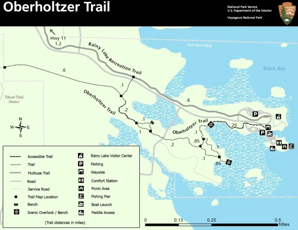
Level of Difficulty: Easy
Hiking Distance: 1.7 miles
Hiking Time: 45 minutes, round trip
Winter Use: Snowshoe
Travel from just outside the Rainy Lake Visitor Center to two overlooks to see the diversity of forest and wetland types in the park. This trail is wheelchair accessible for the first 1/4 mile. Pets are no long allowed on this trail.

Map of Oberholtzer Trail at Voyageurs National Park in Minnesota, showing trail paths, visitor center, parking, benches, scenic overlooks, restrooms, and amenities along the Rainy Lake shoreline. Trail length and water are indicated. | Rainy Lake, MN

1797 Town Road 342, International Falls, MN 56649

Related

A rocky shoreline covered with green pine trees sits beside the calm waters of Rainy Lake, Minnesota, under a pale sky. | Rainy Lake, MN

Anderson Bay Trail

Map of Voyageurs National Park and surrounding area in Minnesota, including Rainy Lake, showing snowmobile trails, safety warnings, lodging locations, trailheads, and amenities. Key and legend at the bottom; colored lines indicate routes and trail conditions. | Rainy Lake, MN

Arrowhead State Trail

A large outdoor gathering of people with numerous off-road vehicles parked on a grassy field near Minnesota’s Rainy Lake, surrounded by trees. Several tents and canopies are set up beneath an overcast sky with grey clouds. | Rainy Lake, MN

ATV Voyageur Country Trail System

A group of people ride horses in a line through a sunlit, dusty field near Minnesota’s Rainy Lake, with a cowboy in a plaid shirt and hat in the foreground. Trees and more riders complete the scenic background. | Rainy Lake, MN

Big Falls Horse Camp

A map of Black Bay Skiing and Hiking Trails near Rainy Lake, Minnesota, showing color-coded trails, parking areas, a visitor center, comfort stations, shelter, paddle access points, and a mileage scale. | Rainy Lake, MN

Black Bay Skiing and Beaver Pond Hiking Trail

Trail map of Blue Ox and Alwood/Squaw Lake areas in north-central Minnesota, featuring ATV routes, parking, campsites, picnic spots, service roads, and a map key with navigation tips—ideal for exploring the Rainy Lake region. | Rainy Lake, MN

Blue Ox Trail

A cheeseburger topped with bacon and macaroni and cheese is served with crinkle-cut fries in a basket. Behind it, a Boondocks Bar & Grill sign reflects the welcoming spirit of Minnesota’s Rainy Lake, set on a wooden table. | Rainy Lake, MN

Boondock’s Bar & Grill + RV Campground

Four people in winter clothing kneel on a frozen Minnesota lake, smiling and holding several fish each. More fish are arranged on the ice in front of them, with two off-road vehicles parked nearby—an unforgettable day on Rainy Lake. | Rainy Lake, MN

Border Country Outdoor Adventures

A dark cave entrance is visible in a rocky cliff surrounded by green trees and foliage, with water from Rainy Lake at the base of the rocks in the foreground, nestled in scenic Minnesota. | Rainy Lake, MN

Bushyhead Mine Tunnel